

Engineers in South Korea have developed a monitoring system that combines three technologies to detect hidden ground settlement beneath urban subway lines.
Ground settlement – the downward movement of the ground surface or soil caused by changes in underlying rock or soil – poses a growing risk to underground infrastructure as cities continue to develop underground space.
Because settlement is difficult to predict, continuous monitoring over wide areas is considered essential for public safety.
Existing techniques have limitations when used alone. GPS-based monitoring cannot measure deformation in underground structures, as signals cannot penetrate solid ground. Satellite-based Interferometric Synthetic Aperture Radar (InSAR) can track deformation over large areas and long periods, but its readings can be affected by observation geometry and atmospheric delays, complicating interpretation.

A research team led by Tae-Yong Park, a master’s student in the department of civil engineering at Seoul National University of Science and Technology (SEOULTECH), has developed a forensic multi-scale remote sensing (MSRS) framework that integrates InSAR, laser scanning and ground penetrating radar (GPR).
“This innovative fusion of technologies enables not only the detection of ground settlement but also the investigation of its underlying causes,” said Park. “Particularly, our approach allows problems associated with excavation, inadequate compaction and other construction defects to be characterised in greater detail than would be possible by using any single technology.”
The study was published in Tunnelling and Underground Space Technology last month.
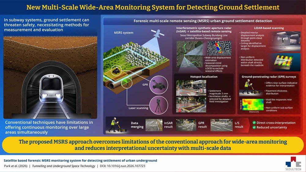
The framework was tested along the Seoul Metropolitan Subway Bundang Line, over a 16km corridor between Suseo Station and Cheongnyangni Station, and operates in three stages.
First, InSAR time-series analysis measures long-term settlement across the whole corridor by comparing repeated radar signals over the same area. The team applied a technique called “seasonal-trend decomposition using LOESS” to filter out seasonal fluctuations. This analysis identified a ventilation shaft showing a distinct, progressive settlement signal, which was selected for further investigation.
Second, laser scanning was carried out at the shaft, using LiDAR to build digital point-cloud models and quantify structural change. Visual inspection had already found cracks and repair marks on the ceiling; the scanning showed the settlement pattern becoming more pronounced beneath the roadside above the shaft.
Third, GPR was used to survey the road section above the shaft. The survey detected signals consistent with void-like structures near the shaft and reduced continuity in subsurface layer boundaries, indicating non-uniform ground conditions.
Cross-referencing the results from all three methods showed the settlement anomaly was consistent across techniques rather than an artefact of any single dataset, which the researchers said reduces the uncertainty associated with relying on one method alone.
“Our research could help shift the paradigm of urban disaster management from reactive response to proactive prevention,” said Park. “In the long term, the MSRS system will support timely maintenance and targeted investigations of high-risk areas, thereby reducing the risk of sudden sinkholes, structural damage and infrastructure failure.”
Image credit: @nasa/Unsplash
Read next: AI tops the bill at UKCW digital stage
Are you a building professional? Sign up for a FREE MEMBERSHIP to upload news stories, post job vacancies, and connect with colleagues on our secure social feed.
