
The launch of the National Highways Network Model marks a new era in data-driven transport management
A new digital model of England’s motorways and A roads promises to make journeys safer, more efficient, and more sustainable, while saving the economy millions. Developed by National Highways in partnership with Ordnance Survey (OS), the National Highways Network Model represents a landmark step in the digital transformation of the UK’s road infrastructure.
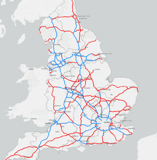
Built upon trusted Ordnance Survey data, this model provides the most detailed, accurate, and comprehensive digital representation of the Strategic Road Network (SRN) ever created, covering more than 4,500 miles of motorways and major A roads across England.
The initiative marks the start of a new strategic partnership between National Highways and Ordnance Survey, underpinned by a shared goal: to deliver intelligent, data-led infrastructure that enhances mobility, safety, and productivity.
A detailed digital twin of England’s major roads
The National Highways Network Model functions as a form of digital twin for the SRN, bringing together nearly 30 distinct data layers. These include key attribution data such as:
- Road names, classifications, and precise locations
- Lane counts and widths
- Transport links and node connections
- Height, weight, and speed restrictions
By combining OS MasterMap Highways Network data with National Highways’ own datasets, the model establishes a single, authoritative version of England’s road network. Importantly, it also introduces a mechanism for continuous improvement, allowing users to report data quality issues and contribute to ongoing refinement.
This unified geospatial foundation ensures consistency across five National Highways APIs, which provide live data on road and lane closures, diversion routes, and planned maintenance, enhancing collaboration between local authorities, logistics providers, and technology developers.
Supporting smarter, safer and more sustainable journeys
The Strategic Road Network is at the heart of England’s transport system, carrying around a third of all traffic and two-thirds of all freight. According to National Highways, delays across the SRN and wider network cost the economy around £3 billion per year.
With accurate, real-time geospatial data, the new model can play a pivotal role in reducing congestion, improving journey times, and supporting more sustainable road use. It provides critical insight for decision-makers across government, logistics, and the construction and infrastructure technology sectors.
Through the Digital Lab Open Data Hub, the Network Model is now publicly available, allowing developers, planners, and local authorities to integrate authoritative road data into their own tools and platforms.
This open-data approach supports the wider digital construction ecosystem, enabling:
- More efficient planning of roadworks and diversions
- Smarter freight and logistics routing, reducing idle times and emissions
- Enhanced road safety, with real-time updates on closures, restrictions, and hazards
- Improved collaboration between national and local networks
Car manufacturers and mobility service providers can also connect directly to the data, feeding updates into in-vehicle navigation systems and navigation apps, helping road users plan safer, smoother, and more efficient journeys.


Driving innovation through data collaboration
The collaboration between National Highways and Ordnance Survey sets a precedent for how geospatial data can underpin innovation in national infrastructure.
A dedicated secondment from OS to NH will support the next phase of model development, ensuring the partnership continues to evolve and deliver tangible value for both the public and private sectors.
“The efficiency of the Strategic Road Network plays a vital role in driving economic growth and supporting environmental goals,” said John Kimmance, Chief Customer Officer at Ordnance Survey.
“By using the most trusted and accurate data as a foundation, National Highways has developed an innovative tool designed to enhance journey safety and efficiency while enabling cost-effective planning across sectors.”
Davin Crowley-Sweet, Director of Digital Technical Competence at National Highways, added: “Our partnership with Ordnance Survey is a major milestone as we evolve into a connected data services provider. By making the Network Model publicly available, we empower our partners, from local authorities to researchers, to enhance services, improve efficiency, and innovate.”
Unlocking value across the digital construction ecosystem
The National Highways Network Model exemplifies how digital infrastructure and geospatial intelligence can drive smarter investment decisions and sustainable growth.
By offering a unified, accurate source of truth about England’s key transport arteries, the model supports:
- Infrastructure asset management and maintenance planning
- Digital twins and simulation for construction projects
- Predictive analytics for congestion and travel demand
- Improved resilience in supply chain logistics
- Evidence-based policymaking and academic research
As the UK continues to invest in smart infrastructure and connected mobility, initiatives like this demonstrate the transformative potential of open data and collaborative digital ecosystems.
Accessing the National Highways Network Model
The Network Model has been approved for release under the Open Government Licence, ensuring accessibility for organisations across the public, private, and academic sectors.
It is available now via:
- National Highways Open Data
- data.gov.uk
- Living Atlas
This marks a new chapter in the UK’s journey towards an intelligent, data-enabled transport network, where collaboration, innovation, and digital transformation combine to deliver safer, more efficient, and more sustainable roads for all.
Read next: Celebrating digital construction excellence – Build in Digital
Are you a building professional? Sign up for a FREE MEMBERSHIP to upload news stories, post job vacancies, and connect with colleagues on our secure social feed.