

Digital Earth Africa has launched a new tool that uses satellite data to provide decision-makers with vital insights on coastal erosion and human development in the continent’s coastline nations
Coastlines across Africa are undergoing rapid changes due to a combination of rising sea levels, more frequent extreme weather events triggered by climate change. The impact of urbanisation and coastal population growth isn’t helping either.
This poses significant challenges for sustainable development in Africa’s coastal regions, requiring comprehensive monitoring and adaptation strategies to mitigate the impacts on infrastructure, agriculture, and public health.
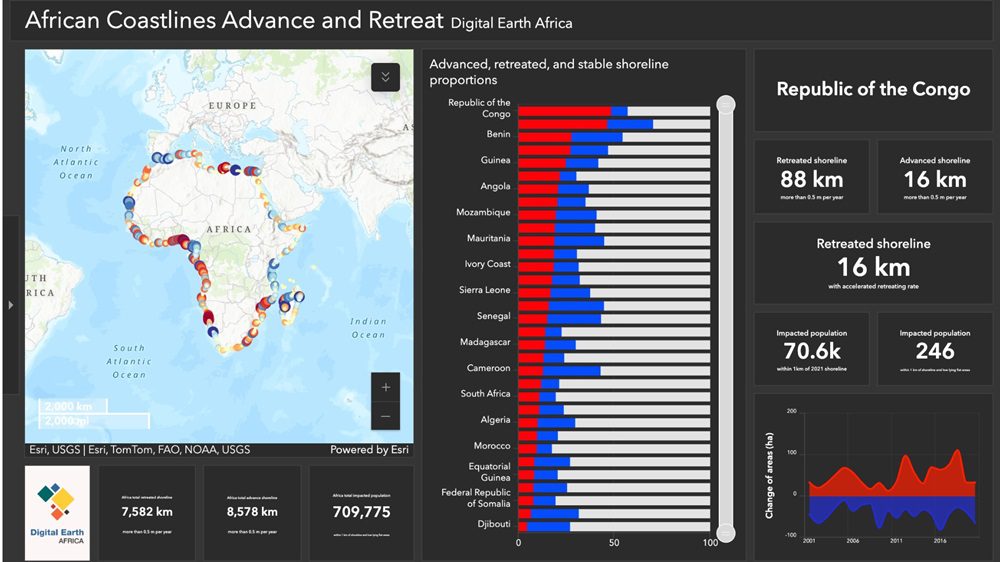
That’s where Digital Earth Africa comes in, with a new Coastlines Monitoring Service dashboard that uses satellite Earth observation data to map and track the growth and erosion of the African coastline over time, providing vital insights for decision-makers.
With data coverage spanning the entire African coastline over the last 24 years, the service is said to be a valuable resource for monitoring and mapping rates of coastal erosion and change, evaluating the impact of coastal management, as well as responses to changing conditions such as extreme weather events and human development.

Dr Lisa-Maria Rebelo, lead scientist at Digital Earth Africa, said: “Our goal is to equip government agencies and local authorities with the knowledge necessary to make informed decisions and develop effective strategies for managing coastal erosion and its associated risks.
“This service aids in understanding past changes to coastlines, and identifying future areas of concern. Through this tool, we can safeguard vulnerable coastal areas and communities, and ensure the resilience and sustainability of our coastlines for future generations.”
This initiative is said to be a world-first, and has been uniquely tailored for Africa, by Digital Earth Africa, Rebelo explained
“While a small number of individual countries across the world may generate similar data for their coastlines, no service matches the consistency and continental scope offered by this coastal monitoring tool for African countries,” she said. “It sets a new standard for understanding and responding to the challenges posed by changing coastlines in Africa.”
The dashboard provides national scale summaries for each African country with a coastline, providing essential insights, informing national coastal adaptation needs.
Looking at Nigeria
Using Nigeria as an example, Rebelo explained that coastline data reveals critical findings to inform policy.
“Of Nigeria’s entire shoreline, 417 kilometres are retreating inland at an average rate of 0.5m per year, a trend observed consistently over the past 24 years,” Rebelo said. “However, a 99-kilometre portion of this retreating shoreline has seen an accelerated rate of change in the last five years. Targeting such high-risk areas for intervention enables authorities to prioritise limited resources.”
The data also highlights the human impact in Nigeria. Approximately 1.1 million people live within one kilometre of retreating shorelines, and an additional 176,000 reside in low-lying areas under threat from coastal flooding. This puts the total at-risk population at around 1.3 million.
“Understanding these risks is vital for developing effective adaptation strategies, which may include relocating vulnerable communities, bolstering coastal defences, or implementing broader adaptation strategies,” said Rebelo.
The dashboard further provides tools to examine specific years when significant coastal changes occurred. For example, a major retreat in 2017 in Nigeria likely resulted from a storm surge or a similar event. Such insights allow for the assessment of individual storms and their increasing intensity over time.
Continental scope
On a continental scale, the dashboard shows that 7,582 kilometres of Africa’s shoreline are retreating, while 8,500 kilometres are advancing. These statistics highlight the dynamic nature of Africa’s coastlines.
“Coastal erosion, while cyclical, often redistributes sand, advancing other parts of the shoreline. This process is reflected in advancing and retreating statistics, which balance out when viewed continent-wide,” Rebelo said.
Digital Earth Africa says the ultimate aim of this monitoring service is to empower national governments in their coastal adaptation planning efforts.
By providing detailed, country-specific data, the service supports the identification of at-risk communities, infrastructure, and settlements, guiding targeted interventions.
Going forward, it is expected to play a crucial role in managing Africa’s coastlines, protecting the environment, and supporting sustainable development goals.
Image credit: PIRO from Pixabay
Read next: Scientists make light work of new AI processor
Are you a building professional? Sign up for a FREE MEMBERSHIP to upload news stories, post job vacancies, and connect with colleagues on our secure social feed.
